Old Burial Ground Moves to the Top of Southborough’s Most Endangered List After Clear-cutting of Adjacent Parcel


The newly clearcut triangle between St. Mark’s Street at left and Marlborough Road at right, looking north. Click any picture to enlarge.

Dear Friends,

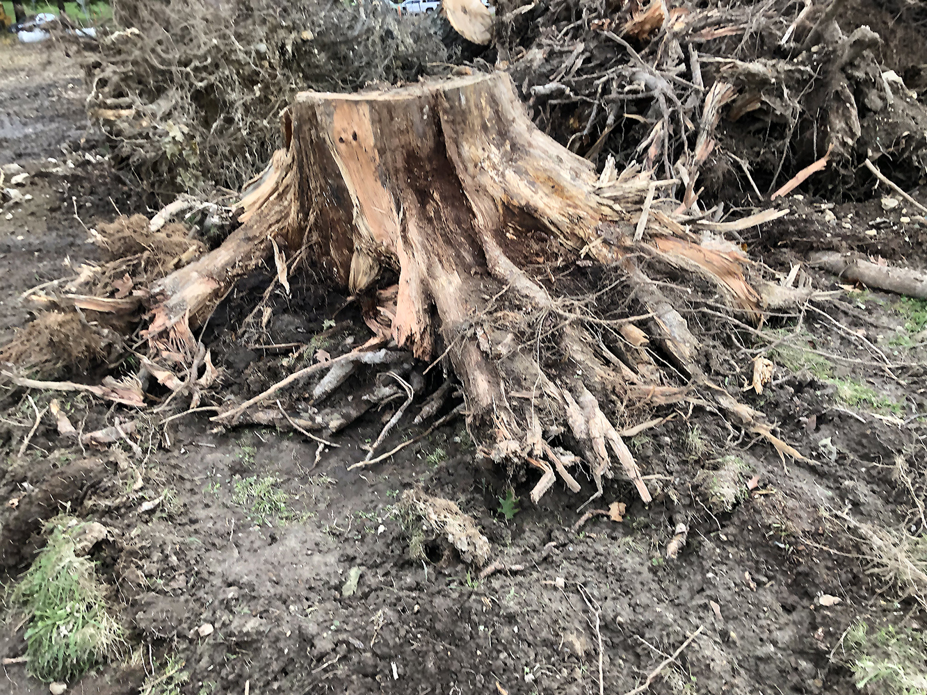
I would like to share with you a letter I wrote to the relevant Town Board and state agencies as Chair of the Historical Commission regarding the wholesale clear-cutting of the parcel adjacent to the Old Burial Ground. Though this parcel is entirely owned by St Mark’s, the town has apparently reached some license agreement—vetted by neither the Planning Board or the Historical Commission, to reroute St. Mark’s street in order to enhance the sports parking area for the school and create a pocket park. Apparently, the Town is using state funds to do this project, and St. Mark’s is paying for some?—though who is paying for what remains unclear at this point. Unfortunately, this ill-conceived project threatens to unearth human remains and has now destabilized the entire remaining Old Burial Ground tree cover.


The plan for the entire triangle. Click to enlarge.

To: Southborough Select Board; Southborough Planning Board; Southborough Open Space Commission; The Southborough Historical Commission; Mark Purple, Southborough Town Administrator; Brona Simon, Executive Director, Massachusetts Historical Commission and State Archeologist; Southborough Historical Society; Karen Galligan, Southborough Director of Public Works.

1 November 2021

As chair of the Historical Commission, I am writing to express extreme concern about the current road and park project along St. Mark’s street at the corner of Marlborough Road (Rte. 85).


Plans continue for a discontinued playground

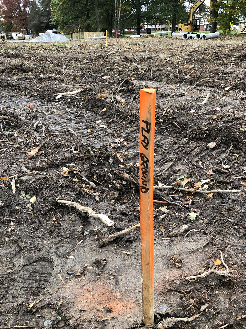
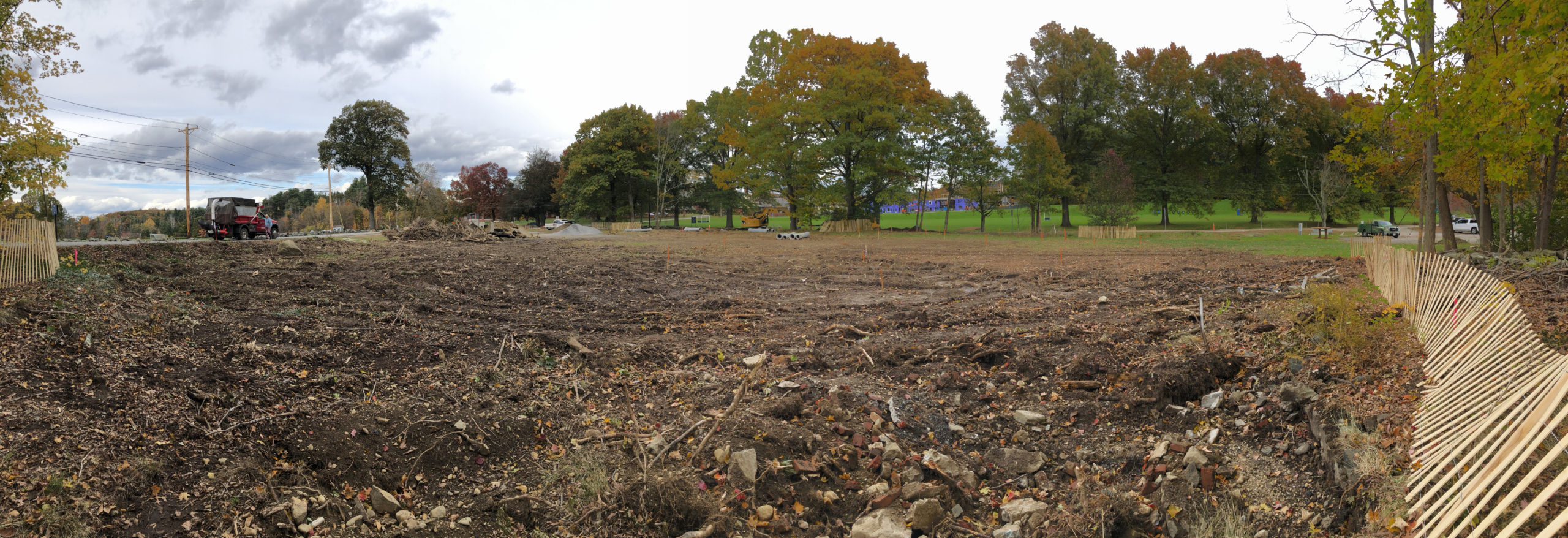
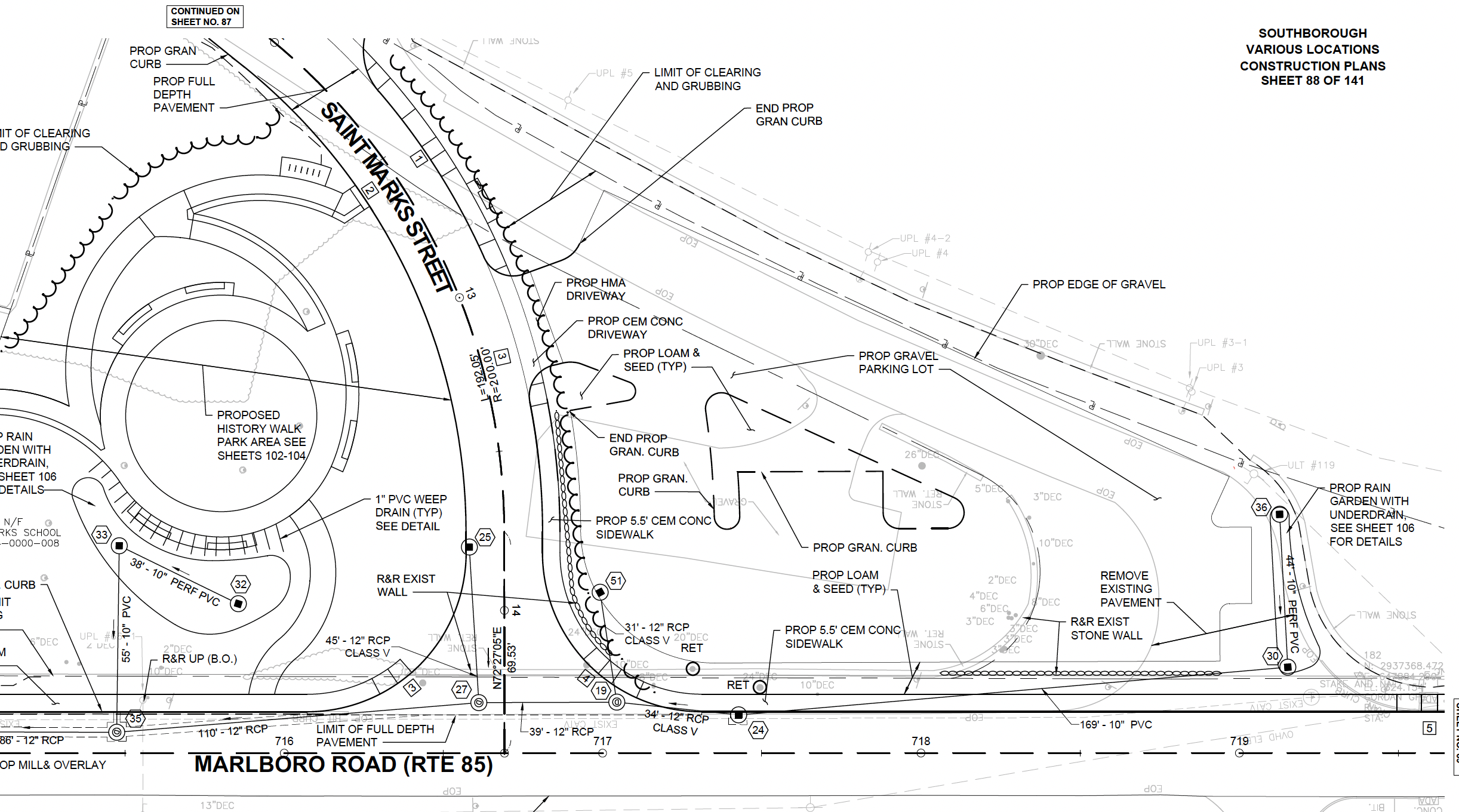
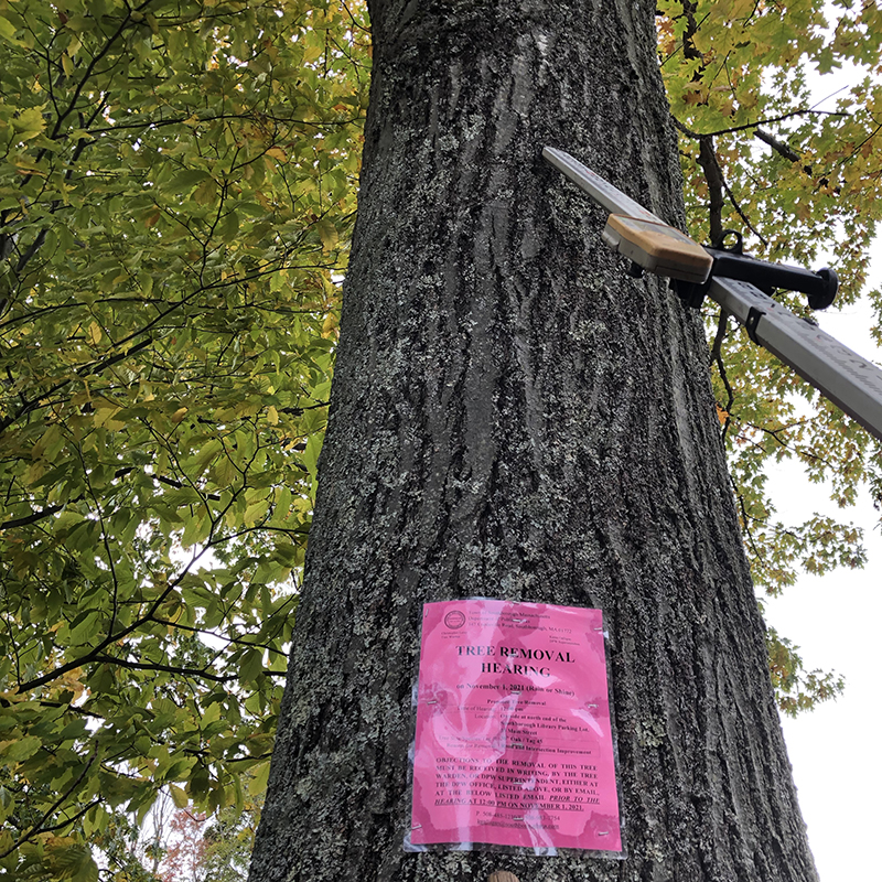
Although the Southborough Historical Commission had seen some conceptual plans for a park and history-walk back in the spring, we had not heard about it since, and presumed the project dead. Suddenly last week, the entire triangle bordering the Old Burial Ground, Cordaville Road, and St. Mark’s Street was clear-cut over a period of two days, without consulting either the Historical Commission or seeking the required Planning Board site review and approval. After speaking with Karen Galligan, the DPW head, it now seems that the project is proceeding using only a conceptual plan, with major elements such as the history-walk and playground arbitrarily deleted. With the educational and entertainment features eliminated, what exactly is the point of this project except facilitating expanded parking for St. Marks School?


The plan showing the entire triangle, with park to the left and parking area to the right. Click to enlarge.


Had the Commission been consulted before construction began, we would have again warned the Board of Selectmen that previous ground radar surveys have indicated numerous colonial-era interments outside of the current Old Burial Ground (OBG) walls. Additionally, the wooded parcel that was cleared last week was also the most likely location of the original pre-contact Native American burial ground. Further soil disturbance so close to the OBG risks disinterment of human remains.

A man-made structure unearthed just outside the OBG walls. Crypt? Old Wall? Who knows without a proper archaeological inspection.


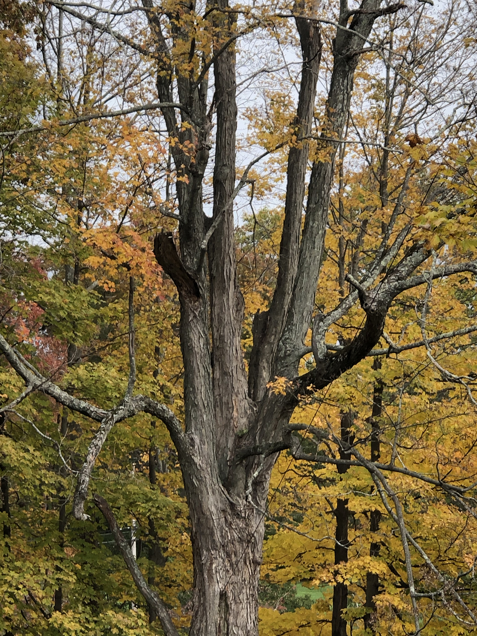
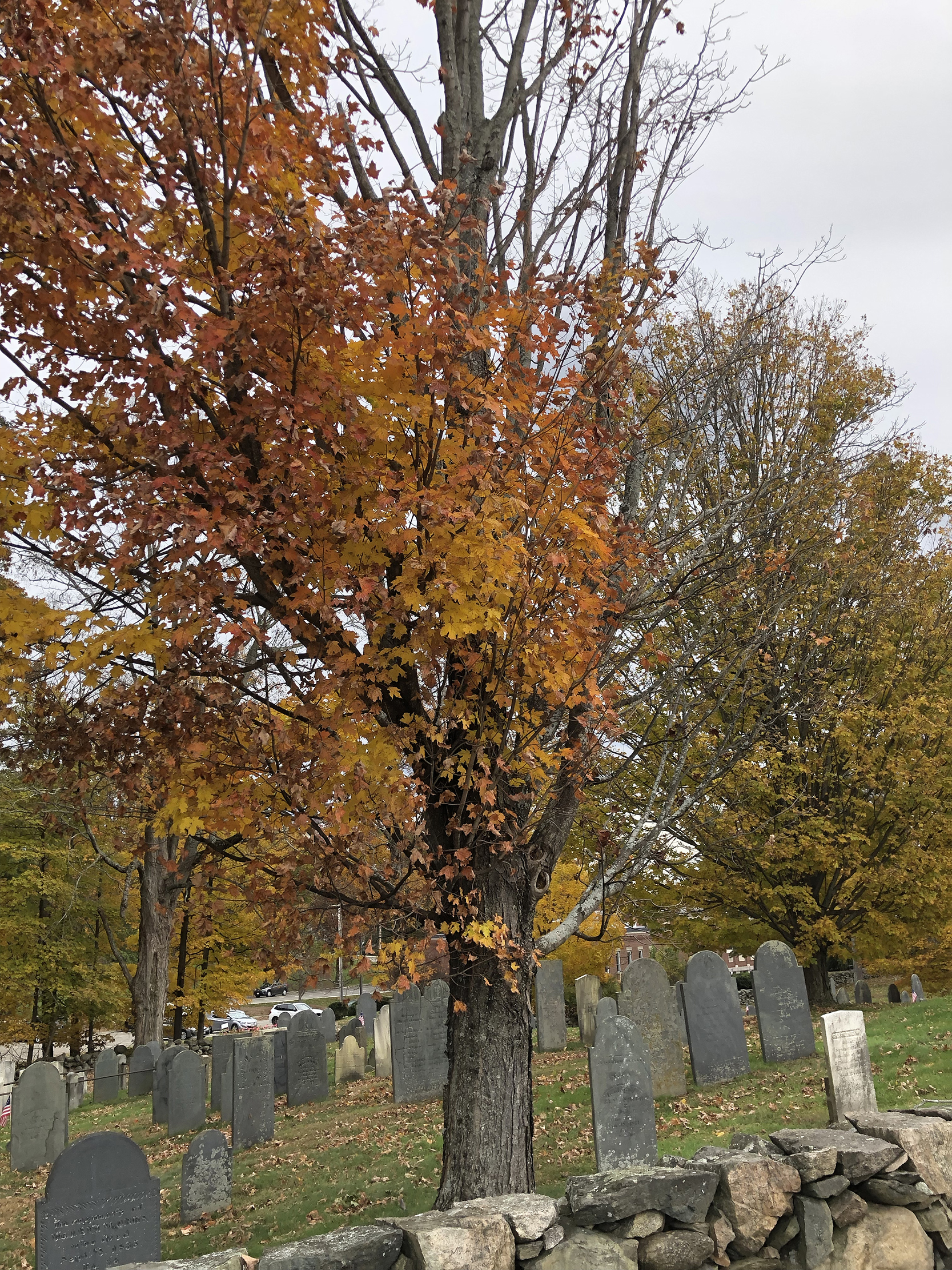
Equally critical, the clear-cutting of century-old woodland has now destroyed the windbreak for the trees in the Old Burial Ground, which were already in extremely precarious condition. With this protection removed, the OBG trees will now be highly susceptible to storm damage, which in turn risks the historic markers below.

One of the few remaining street trees I have objected to removing. The decision now moves to the BOS meeting this Wednesday 11/3. Please attend if you can.

Following the Historic Commission’s stated objection about felling trees on scenic roads, I have formally objected to the removal of any further trees on the site, in particular those along Marlborough Road.

Additionally, I would strongly advise the Board of Selectmen to work with the Historical Commission to fund an emergency professional tree survey of the Old Burial Ground with the idea of assessing the state of the remaining specimens, and doing any required pruning or removal before the onset of the winter storm season, in order to mitigate further damage to the burial stones. Long-term, there needs to be a proactive tree and marker restoration plan with sufficient annual funding to preserve the integrity of our most precious historical asset. There should also be a permanent marker acknowledging the Native American presence in this area.

Called widow makers for a reason, large dead branches like this can easily damage the historic markers below.

Regarding the park itself, in my professional capacity as the head of a landscape architecture firm, I have reviewed the proposed planting plan and design, and found them extremely lacking. The plant selection is poor and makes no provision for climate change. Even more worrisome, the entire design was conceived around a central play area that has been eliminated, rendering the current layout useless.

The design for the dead tree berm.

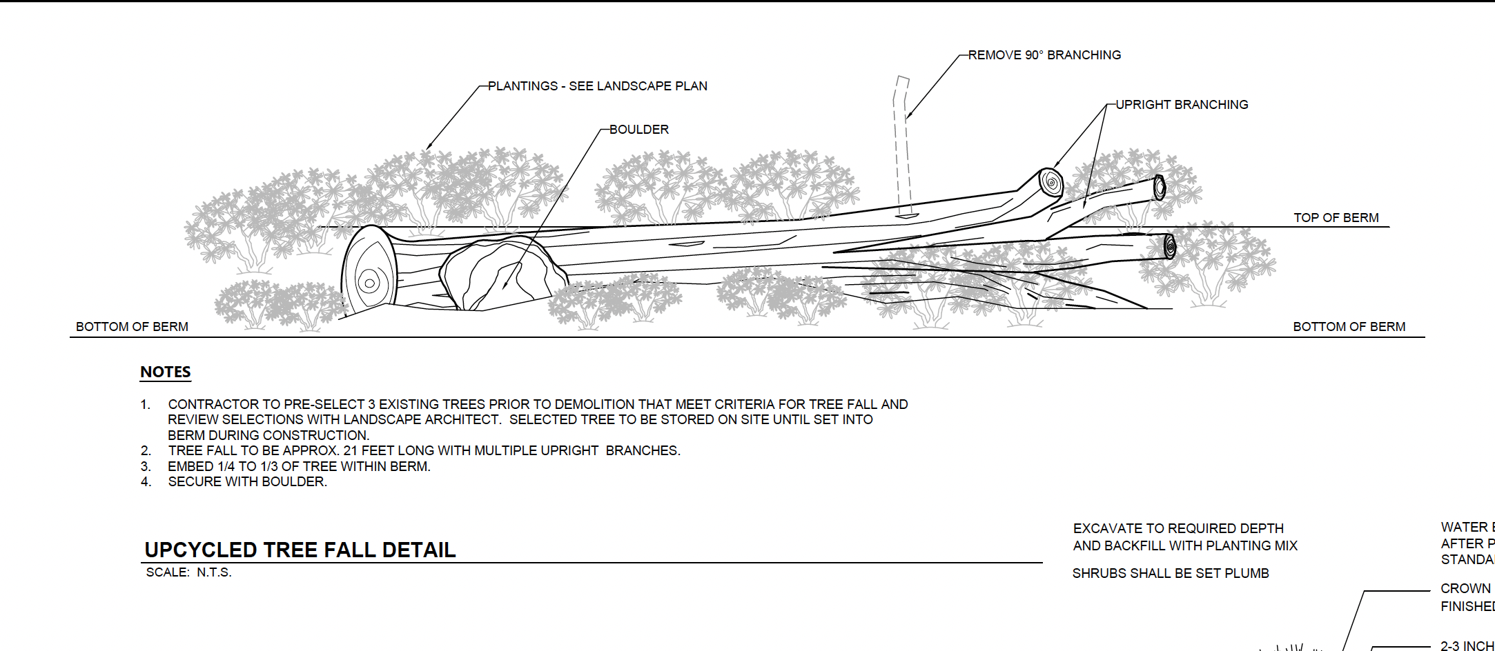
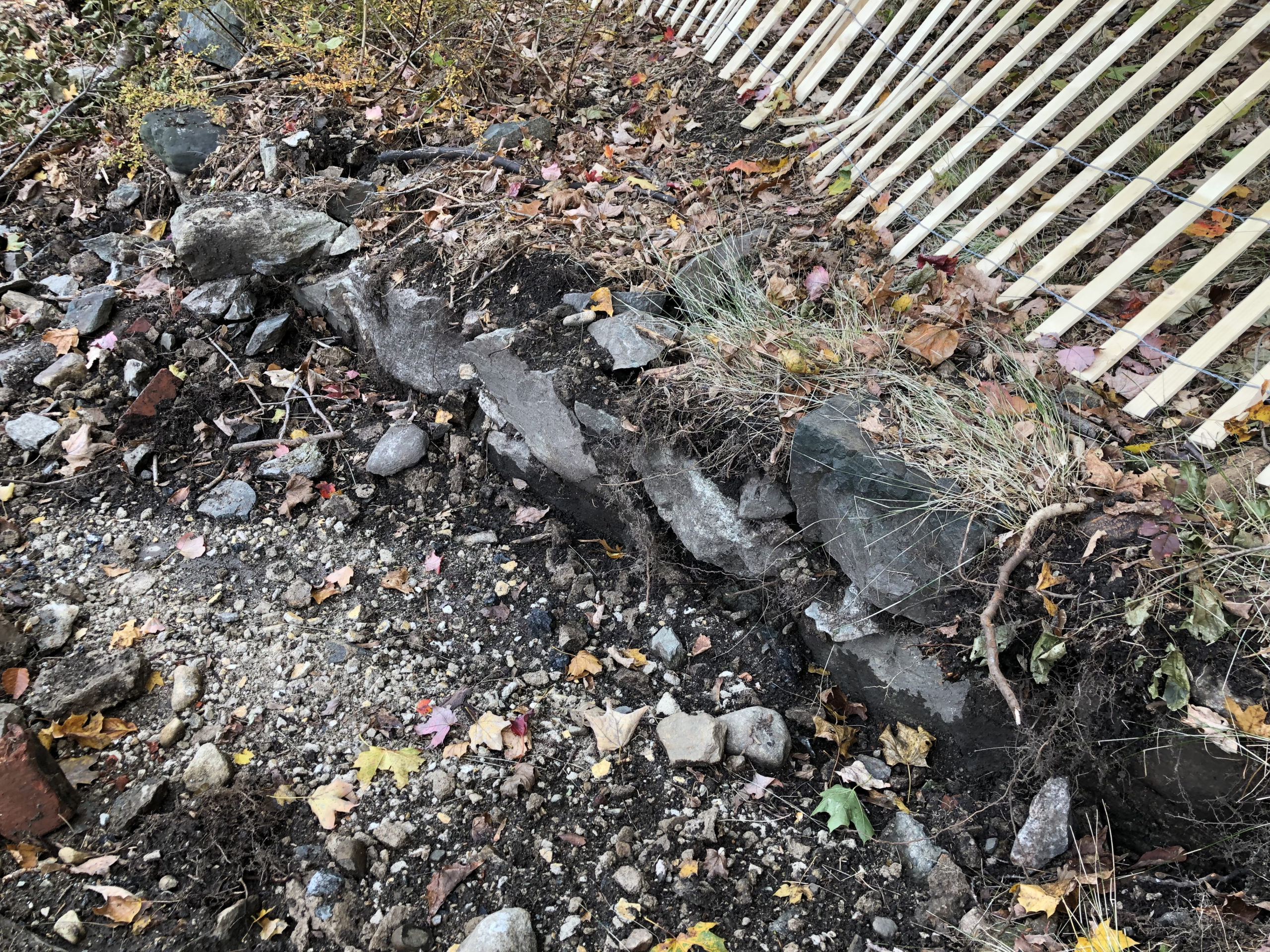
In particular, the proposal to cut down three large trees and use them sideways as some sort of tree-sculpture-berm-structure borders on the absurd, as after only a short period of ground contact, these trees will rot and create a huge legal liability for the town should anyone climb on them. There is also the issue of the historic stone wall along Marlborough road that will be destroyed if the current plans are implemented, violating our own preservation bylaw.

A typical tree in the OBG. The right side hasn’t lost its leaves, it is dead.

I would urge the Select Board to halt this project immediately until it can be thoroughly reviewed and approved by the Town Boards which should have been consulted before construction began: namely, Planning, Historical and Open Space. It remains unclear how much—if any—use by town residents the current “park” would have on such an isolated site without any attraction. The entire concept should be thoroughly reconsidered. Whatever else may happen to this parcel in the future, it is critical the area bordering the Old Burial Ground not be further disturbed, the expansion of the St. Mark’s parking area be visually mitigated, plans be made to restore the tree cover along the boundaries of the triangle, and immediate steps taken to preserve the existing trees and markers in the OBG.

Hard to believe this massive stump was a 100′ living oak a week ago.


More Treasures from the Basement


As I hinted last time, the basement hasn’t finished yielding up its social history treasures, for along with the Franklin Institute minutes, two weeks ago we also rediscovered the accounts of the Young Mens Lyceum.  As a document of social history, it is impossible to underestimate the value of this remarkable record.

The Lyceum was a debating society, much like the earlier Franklin Institute.  But this time, the notation covers the years between 1840-1861, perhaps one of the most turbulent periods in United States history, often referred to as the “Silver Age.” For in addition to the much debated Mexican-American War, our  expanding nation was dealing with the growth of  industrialization, a rapid rise in immigration, and the slow fragmentation of the Union over the issue of slavery. You might think that the inhabitants of agrarian Southborough would  have worried more about the local weather than the political clouds in Washington, but thanks to this record, we now know that wasn’t at all the case.

Here’s a look at some of the debate topics, with a bit of historical context added in, to give you a better understanding of just how up-to-the-moment our citizenry was:

29 November 1842: Which is the most beneficial to the United States: commerce or agriculture? (Voted 6 to 2 for commerce)
This is a very interesting result for what was then entirely agricultural Southborough, and shows that the rising tides of industrialization were beginning to spread out along the lines of the new railroad. Within the next decade, in fact, Southborough would have its first large-scale mill at Cordaville.

The mills at Cordaville originally produced cheap cotton cloth for the Southern slave markets, and only later turned to woolen blanket production,  highly ironic considering the fierce abolitionist stance of many Southborough inhabitants.

21 March 1843:  Have females the right to active part in public affairs? (Voted yes) The Lyceum, unlike the Franklin Institute, also seems to have had  a female “editress,” whose job appears to have been gathering news-bits of the day for presentation to the members.

22 February 1844: Is it right or expedient to prosecute vendors of spirituous liquors? (Voted 5 to 4 yes.) 
Massachusetts was technically dry during this period, but sellers of hard liquor weren’t hard to find, and the close vote is indicative of the popular stance — publicly opposed but privately for.  The state would try various solutions until eventually agreeing to license liquor vendors in the 1870s. Southborough remained officially dry even longer, and our thirsty citizens needed to cross the river to Hopkinton, where  those in search of  liquor, cards and other pleasures could find several famed houses of mixed repute.

Henry Clay, the “Great Pacificator”

23 September 1844: Can abolitionists consistently vote for Henry Clay? (Voted 2-6 against)
1844 was a presidential election year, and Henry Clay, the Whig candidate, was running against Democrat James Polk. Polk, from Tennessee, was a slave owner. Clay, from Kentucky, had also owned slaves, but was considered “soft” on slavery as he decried the institution and favored gradual emancipation and repatriation of slaves to Africa — a view shared at the time by Abraham Lincoln. Southborough, however, was a hotbed of abolitionists, and true to their convictions, the Lyceum members could not bring themselves to support Clay, despite his carrying the rest of the state.

24 December 1844: Are rewards of merit conducive to the best interests of our common schools? (Voted 4-5 against)
Corporal punishment was still a favored means of discipline in our schools in 1844. This practice would change markedly over the next twenty years, as Southborough formed a school committee and introduced semi-permanent female teachers, as opposed to the previous system of interim male tutors. Note, too, the date: 24 December. Christmas as a major holiday was still decades away, to be popularized by Queen Victoria’s German consort, Prince Albert.

3 March 1847: Ought the so-called free states remain in the Union? (Voted not to remain.) A very hot topic, this question was debated again on October, 6th, 13th and 20th. The vote taken on the 20th, 9-1 to remain in the union, reversed the previous opinion. Still not settled, the question was taken up once more, on November 16th and 22nd, this time the results being far closer, 8 to 6 to remain. This back-and-forth is truly fascinating, as it reveals that Southerners weren’t the only ones contemplating secession — something that’s never mentioned in our history texts — and that the residents of Southborough were more or less divided on the question. Imagine if the North had seceded and left the South to its own devices!  Alternate historians have speculated that lacking the industrialized north, the Southern states would have looked to the Caribbean and Central America for resource markets, extending slavery throughout the region.  A very different world indeed….


4 November 1848: Can a true patriot vote for Cass or Taylor for President at the coming election?

1848 was another presidential election year, and this time the candidates were even less palatable to the Lyceum members. Taylor, though nominated by the Whigs as the hero of the Mexican-American War, shared none of their values. Cass, a Southern Democrat, (though he was born in New Hampshire) was equally unacceptable. That left former president Martin Van Buren, who

Results of the 1848 election

ran as an independent.  The record of the Lyceum says it all: “The question was discussed for an hour and half but with little earnestness owing to the fact that there being no one to oppose from principle, and it was then decided 4-1 in the negative.”  This result should give some heart to modern day residents: it appears that the 2016 election wasn’t the first  where voters went to the polls holding their noses.

24 January 1849: Which contains the greater evidence of a supreme being, nature or the bible? (Voted Nature 5-1)
Given the Pilgrim founding of Southborough, this is another really interesting result, as you might have expected  more traditional religious views, but it seems that our Lyceum members shared more than a little streak of transcendentalism.

28 February 1850: Which has been treated worse, the Indians or the Negros? (Voted 7-1 for the Indians)

20 February 1850:  Is it probable that the country will be benefited on the whole by the discovery of gold in California? (5 to 4 against)
Southborough wasn’t immune to the call of California gold, and the Society possesses a fascinating series of letters from a former resident who left to try his luck — but that’s a story for another day.

23 February 1850: Which is worst, the slanderer or the thief? (Voted 4 to 2 for the slanderer)

16 October 1850: Ought Massachusetts sustain the Fugitive Slave Bill? (Decided unanimously against)
The Fugitive Slave Act, part of Henry Clay’s Great Compromise of 1850, allowed anyone suspected of being a fugitive slave to be arrested on merely the claimant’s sworn testimony of ownership. The law was widely despised and resisted in the North, as the residents of Southborough clearly reveal here.

31 March 1852: Is a monarchical or republican form of government better adapted to the promotion of the arts and sciences? (Voted  3-10 for the republic)

Great Britain has just hosted the Crystal Palace Exhibition showcasing British industry and arts, and this question is undoubtedly the result of some nationalistic chaffing.  Americans would have to wait until the Centennial Exhibition at Philadelphia in 1876 to see something similar.

22 December 1852: Should the annexation of Canada be encouraged? (8 to 6 for)
There was serious discussion in both the US and Canada (especially Quebec) about annexing all or part of Canada to the US, which wasn’t as far fetched as it sounds to us today. The Dominion of Canada had yet to be formed, and many viewed the territories to the north as ripe for acquisition, as the Alaska Purchase would confirm in 1867.

27 December 1859: Is the reading of fiction beneficial to society? (Voted no)
So much for Dickens! Interestingly, the Society, in conjunction with the Library, possesses the 1852 founding documentation (including book lists) for our Library, and its one of our future projects to study and digitize these records. It would be interesting to see exactly what books were considered “beneficial.”

3 January 1860: Is John Brown to be justified in his conduct at Harper’s Ferry? (Voted yes)
The 1859 raid on Harper’s Ferry was an effort by abolitionist John Brown to initiate an armed slave revolt by taking over the United States arsenal at Harpers Ferry, Virginia. It was put down by the US Marines, and Brown, a long-time resident of Springfield Massachusetts, was tried and hung for treason. That the residents of Southborough would support this violent action is indicative of just how fiercely anti-slavery many of the Town residents had become.

24 January 1860. Is one nation justified in forcing civilization upon another? (Voted no)
An astoundingly modern view, given the nationalism of the Victorian age.

26 March 1861: Should foreign immigration be encouraged? (Voted 15-6 no)
Hardly surprising in Southborough where the founding Yankees were beginning to feel the pressure of Irish immigration.

9 April 1861: The very last entry of this incredible record. The Civil War was about begin and soon many members would be putting courage to the same convictions they had earlier professed at the Lyceum.

“Owing to the small number present,” reads the record,  “it was thought best to have no discussion. Voted to adjourn sine die.”

And thus the golden age of Southborough’s debating societies came to a muted end, drowned out by the drums of civil war.

Neither the Town, nor the Nation,  would ever be quite the same again.


On the Indian Trail, Literally

Indian Trails of the 17th and 18th centuries

In preparation for expanding the Native American presence at the Museum, I’ve been reading a wonderful book Indian New England before the Mayflower and I came across a very interesting map: “A compilation of certain recorded northern New England Indian trails and villages of the 17th and 18th centuries.” Something about this looked really familiar, so using one of the online map overlay services, I decided to place the Indian trail map over the modern road grid in Massachusetts, Connecticut and Rhode Island.

Wow!

Now I have long known that Main Street and Cordaville Roads in Southborough follow Indian trails, but I didn’t realize so did most of our existing major highways. It’s like the Roman roads in Italy!

Some examples from a cursory review:

Rt 1A its entire length
Rt 2 west of Worcester to the NY border
Rt 3 all the way to the Cape, and from Lowell to Nashua NH
Rt 6A entire length
Rts 7 and 8 (in western Mass) their entire length
Rt 10 from Vermont to Connecticut
Rt. 16 between Webster and Watertown
Rt 20 its entire length
Rt 30 most of its length
Rt 44 entire length
Rt 84 to Hartford and New York
Rt 91 through Springfield
Rt 95 all the way to NYC
Rts 110 and 117 majority of route
Rt 126/135­ between Hopkinton and Wayland

I am sure there are others. Take a minute and explore for yourself; just click on any map below to expand.  (Or, you can try the slider version of the map, HERE, using the slider in the upper right hand corner labeled “Indian Map” CAREFUL: IT GETS ADDICTIVE)

I suppose in many ways this should have been self-intuitive, as foot paths became cart-paths that became roads that became highways. But somehow, in our European bias, I think many of us (including me) always imagined the first Pilgrims hacking their way through virgin woodland, creating those paths. But the reality is that the Pilgrims and their successors had stepped into a land that had been tended, cultivated and very much altered by Native Americans for thousands of years. The cleared planting fields were already there, as were the fishing camps and weirs, the tended hunting grounds, even the settlement places. But most fatally for the Indian, the well marked land routes were there too, leading the Europeans ever westward with relative ease — to the eventual doom of their civilization.

Something to think about next time you are stuck in traffic…

Indian Trails with Modern Towns. The circles indicate documented Indian settlements
Indian Trails Superimposed on Modern Roadways
Modern Map

SHS Announces the Discovery of Priceless 17th Century Documents

The Southborough Historical Society is absolutely thrilled to announce the discovery of 13 exceedingly rare early 17th-century documents relating to the Sawin family of Southborough. The items record, among other matters, the 1656 layout of the village of Praying Indians at Natick, the 1686 sale of 5 acres of land there for the construction of a mill by Thomas Sawin, and subsequent grants and transactions. These documents are critically important to our local area history, as they detail the early interactions between the newly arrived settlers of the Massachusetts Bay Colony and the native peoples of this region, the Nipmuc tribe. The Nipmuc, almost entirely forgotten today, had lived throughout central Massachusetts for thousands of years, including sites in Southborough. In fact, the basic layout of Southborough along the lines of Route 30 and Cordaville Road follows the fishing and hunting trails, farming fields and camps sites established by the Nipmuc people many centuries ago.

The 1659 deed laying out the grant of land to the Praying Indians of Natick

The Nipmuc initially welcomed the English to the area, believing there was “enough land for all.” However, tensions rose quickly, as English settlers began proselytize the natives, as well as impose their rigid system of land division on the formerly nomadic tribe. The English held the view that any “empty” land could be assigned to specific owners and enclosed for cattle and other grazing animals, while the itinerant Nipmuc felt that the land must remain open for the common good. Add to the mix the Europeans’ introduction of firearms and alcohol to the native peoples, and an already difficult situation became highly volatile. Our 1656 document is witness to this growing conflict, as it defines the borders of the Natick Village of “Praying Indians”— members of the Nipmuc tribe who had adopted Christianity and European ways —  while conveniently and simultaneously opening up surrounding areas for English settlement. Eventually there were a dozen or so of these Praying Indian villages, including at Marlborough, which led directly to the founding of Southborough. Needless to say, this quasi-coerced religious conversion and assignment to specific “villages” (which the white peoples would later term “reservations”) was resented by the majority of Nipmuc who remained faithful to their traditional ways. The inevitable conflict came in 1675, when the Nipmuc and their allies rose up against the English. The subsequent bloody conflict, essentially a battle fought to determine supremacy between two conflicting cultures, came to be called King Phillips War and marks the birth of one nation, and the death of another.

For the English, who were fighting for their vision of a Christianized New World, the war meant the loss of 1 out of every 10 military age men; 1000 civilian casualties; the complete destruction of 12 of the region’s towns; attacks on half the others; (including Marlborough and Sudbury) and damage to farms, mills and other property sufficient to set the colony’s economy back two decades. Fought entirely without English aid, King Philip’s War also marked the beginning of an American identity separate to that of Europe.


The 1685 deed to Thomas Sawin, sealed and signed by the four elders of the Natick Village.

For the Nipmuc and their regional allies, it meant not only the extermination of their way of life, but their virtual extinction.  Those who didn’t flee were slaughtered by the thousands, and at the end of the conflict the remaining native survivors of the area were rounded up by the English — including the Christianized Indians of Natick and the other Praying Towns — and interned on Deer Island in Boston Harbor where they were left to die of starvation and disease. Hundreds of others were sold into slavery. Eventually, a small number returned to their former homes to live under English rule, but the viability of their culture had been destroyed. Our 1685 document, the Thomas Sawin deed, is an extremely rare survivor of this postwar period, and gives a rare glimpse of what life was like at Natick ten years after King Phillip’s War. The diminished Nipmuc, who had since become accustomed to eating ground corn, were desirous of a mill in their village. So they invited Thomas Sawin, who had already built a mill at Sherbourne, to come live among them and set up a mill. Their offer was 50 acres of land on the stipulation that he and his heirs and assigns were to maintain the mill forever, and that there was to be no other corn-mill built in town without the consent of  Thomas Sawin, his heirs and assigns. Thomas Sawin kept his word, built the mill, and lived peaceably among the natives for the rest of his life, but even more importantly, he became an advocate for native rights at the Massachusetts General Court. This progressive stance would remain the hallmark of the Sawin family,  as we shall see.

Notice of Moses Sawin’s Abolitionist Meeting at Southborough, published in The Liberator, 3 December 1847

So how did these remarkable documents wind up in Southborough? Well, long story short, the answer was the response to another epic battle in American history, the fight against slavery. Fast forward 148 years to 1833 where Moses Sawin is still running his grandfather Thomas’ mill at Natick:

To quote the 1876 History of Southborough by Dexter Newton:

“When the clarion notes of William Lloyd Garrison rang through the land calling the nation to repentance for supporting and main­taining chattel slavery, Mr. Moses Sawin did not hesitate to enlist in the great cause of humanity. He was convinced it was a sin against God and a crime against his brother man.

He had the courage to ask the members of the church to which he belonged to testify against the sin; when his request was rejected he refused to commune with them as a church of Christ, and when, for this refusal, they cast him out of the church, he exultantly quoted to them the words of Christ, viz.: “Inasmuch as ye did it unto one of the least of these my brethren, ye did it unto me.” He was especially gratified that he had lived to see slavery entirely abolished; it was what he had long labored for and sought. But the crowning glory of his latter days was in hearing his former opponents acknowledge the righteousness of his cause, and labor earnestly with him in the overthrow of American slavery.”

So translated to the modern vernacular: Moses Sawin became such an vocal abolitionist that when his fellow Natick church members tired of him and tossed him out, he picked up stakes and moved to Southborough. As Newton relates:

Moses Sawin purchased the grist and saw-mill and a small lot of land situate one-half mile west of Town Hall, in Southborough, of Deacon Gabriel Parker, in 1833. The year following he bought of said Parker seven acres of land adjoining same, and on south side of Mill Pond, and built thereon a spacious dwelling-house, barn and other buildings. The estate is now owned and occupied by Charles B. Sawin, youngest of his three surviving sons. (The sawmill and house are long gone, but were located just south of the MDC damn on Deerfoot Road, which in many ways mimics the Sawin damn and mill pond of old.)

And then comes the kicker:

Said Moses Sawin possessed and carefully preserved through life the curious old deed, signed and sealed by the Indian chiefs of whom his said ancestor purchased the land. They are now in possession of said C. B. Sawin, at the old home-stead, where antiquarians and others interested in curious legal documents can examine them.

And thus, our amazing trove of documents!


The Sawin Mill at Southborough. It sat on Deerfoot road just south of the MDC dam.


The Sawin family remained active in Southborough right up until the 1960s, owning the still extant brick building on Boston Road, now home to Falconi Oil, which was once their feed store. They owned too a large house at 10 Latisquama Road. It seems that when the last Sawin descendants left Southborough sometime in the 70s, they donated their precious family papers to the Southborough Historical Society. The various documents had by then been bound into an innocuous leather volume appropriately labeled Sawin Family Documents, but without any text or explanation. As such, it was dutifully placed on a basement storage shelf, and promptly forgotten.  Then came the 2015 flood, and  these priceless documents narrowly missed inundation. Returned to the Museum from temporary storage this spring, it wasn’t until we began the arduous process of unpacking, rehousing and cataloguing the material did we discover the true value of what had been sitting on our shelves for 50 years. Today, the 13 documents have been carefully removed from their leather binding, which was showing signs of mold, carefully rehoused in archival envelopes, and stored in our new climate-controlled safe.

George Sawin, direct lineal descendant of Thomas and Moses Sawin, inspecting the documents in the newly re-opened Museum conference room

So what’s next? Well, first of all we will digitize these documents and share them with the world. We’ve already been in touch George Sawin, who leads the Sawin Family Association, who’s come to see documents at the Museum, and who, coincidentally, is spearheading the preservation of Thomas Sawin’s endangered 18th century homestead, which still graces the banks of the Charles River at Natick. Next, partially based on this amazing trove, we’ve applied for funding for a new traveling exhibit, “The Nipmuc, the English, and New England’s First Forgotten War” which will debut at the museum in the fall of 2018 and then travel to local area schools and institutions.

The importance of this find can’t be understated. The documents are of Smithsonian-level quality and importance, incredibly rare paper survivors from the earliest days of our nation. We are honored to be their conservators — which we can only do with your continued help and generous support.


Your donations make discoveries like this possible. Please help support the Southborough Historical Society!