The Intrepid Colonel Fay Takes a Trip to St. Louis, Autumn 1836, Part I

The first page of Fay’s account. The letter spans 12 pages written over the period of about a week on the return journey.

Among the Fay correspondence the Society is publishing for the first time ever this winter, we found a remarkable letter that chronicles the almost superhuman effort it took to travel by land before the railroad system linked the continent in the 1860s and 70s.  Although not stated in the account, it seems fairly clear that Fay took on this arduous 1836 journey from Boston to St. Louis to act as a business agent, looking for profitable investment opportunities for wealthy Boston clients.

In this first installment, our hero Colonel Francis B. Fay, late of Southborough, finds himself ill-housed, ill-used, battered about, and eventually, submerged in Lake Erie….

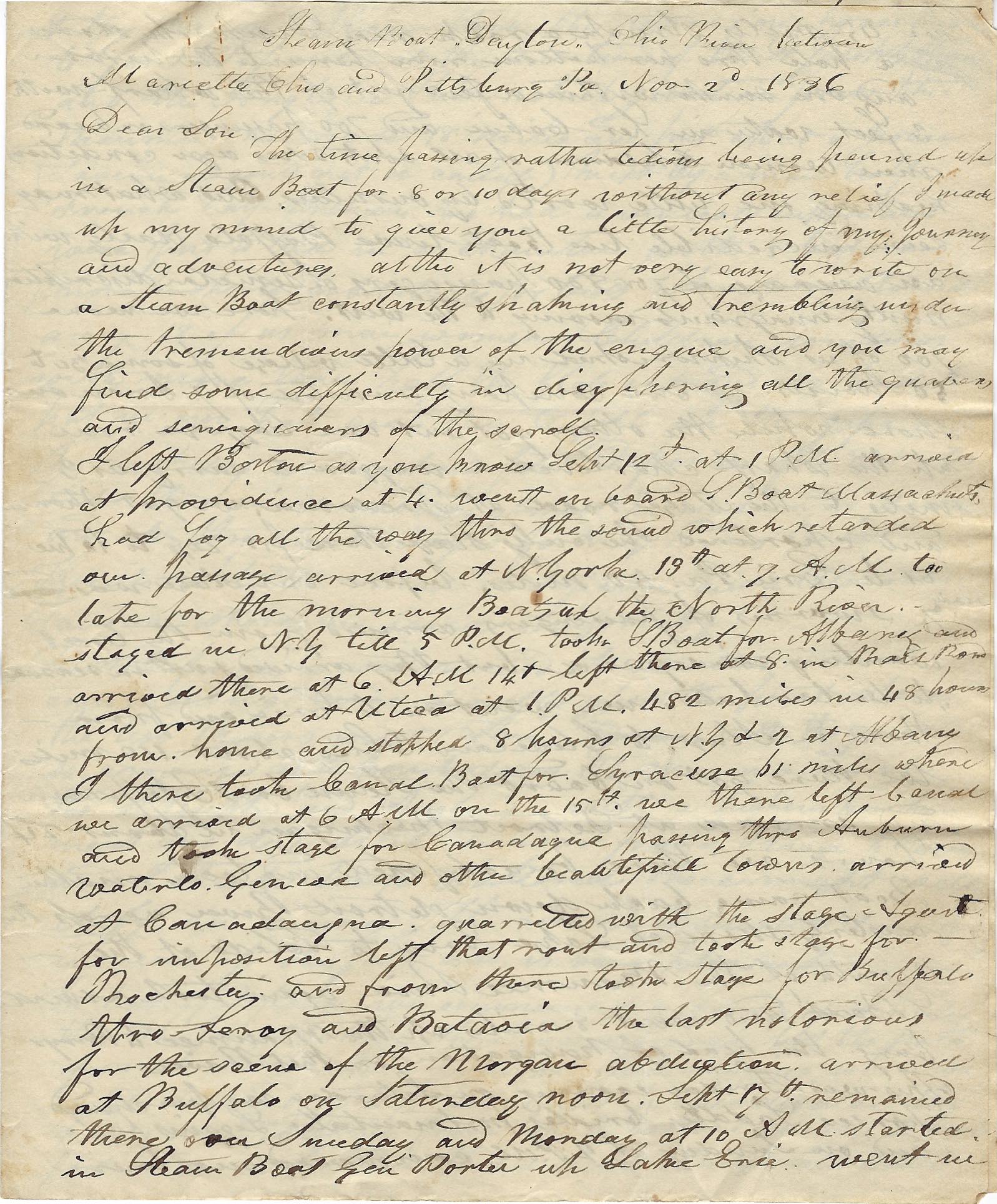
On board the steamboat Dayton, on the Ohio River between Mariette Ohio and Pittsburgh

November 2nd 1836

Dear Lori,

The time passing rather tedious—being penned up in a steamboat for 8 or 10 days without any relief, I made up my mind to give you a little history of my journey and adventures, although it is not very easy to write on a steamboat constantly shaking and trembling under the tremendous power of the engine and you may find some difficulty in deciphering all the [illegible} of the scroll.

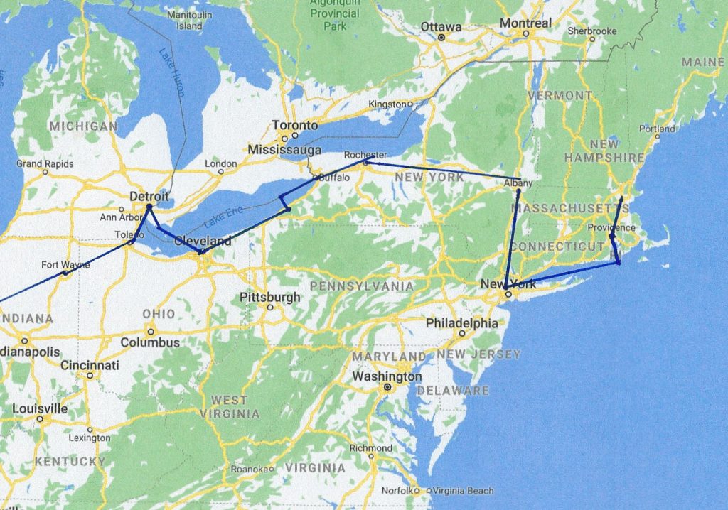
I left Boston, as you know, September 12 at 1 PM and arrived at Providence at 4. [Presumably by the brand-new Boston and Providence Railroad, just finished the year before]. Went on board steamboat Massachusetts, had fog all the way through the [Long Island] sound which retarded out passage, arrived at New York the 13th at 7 AM, too late for the morning boat up the North [Hudson] River. Stayed in New York till five PM, took a boat for Albany and arrived there 6 AM; left there and arrived at Utica at 1 PM. 482 miles in 48 hours from home, having stopped 8 hours in Utica and 2 in Albany.

[This was breath-taking speed for 1836 and would have been a thing of wonder. Compare this to daily sums later in the letter.]

I there took a canal boat for Syracuse—61 miles where we arrived at 6 AM on the 15th. We there left the canal and took stage for Canandaigua passing through Auburn, Waterloo, and Geneva, and other beautiful towns to arrive at Canandaigua. Quarreled the stage agent for imposition, [unclear what this means, though presumably a disagreement about the fare] left that route and took the stage for Rochester and from there took stage for Buffalo through Lenox and Batavia, the last notorious for the scene of the Morgan abduction.

The route taken westbound by Francis Fay. Because there was as yet no train connection between Boston and Albany, the fastest route was by train and boat via Providence and New York. Incidentally, this poor connection to the interior, which would last another 20 years, was one of the principal reasons New York gained prominence over Boston.

[Fay’s reference to the “Morgan abduction” refers to one William Morgan,  a resident of Batavia, New York, whose disappearance and presumed murder in 1826 ignited a powerful movement against the Freemasons, a fraternal society that had become influential in the United States. After Morgan announced his intention to publish a book exposing Freemasonry’s secrets, he was arrested on trumped-up charges. He disappeared soon after, and was believed to have been kidnapped and killed by Masons from western New York. The allegations surrounding Morgan’s disappearance and presumed death sparked a public outcry.]

An early Great Lakes steamboat. Travel by steamboat was fraught with danger: Poor (or no) maps of underwater hazards, no indoor sanitation, and engine machinery that was liable to explode.

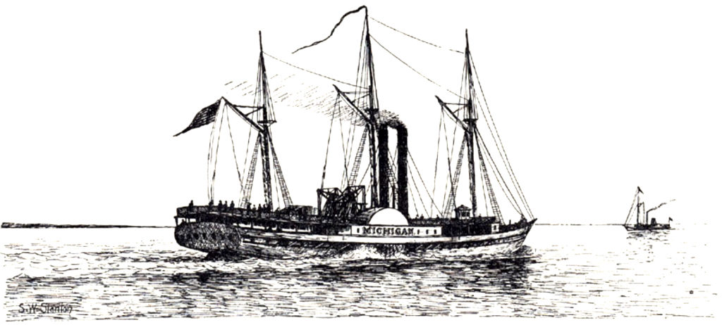
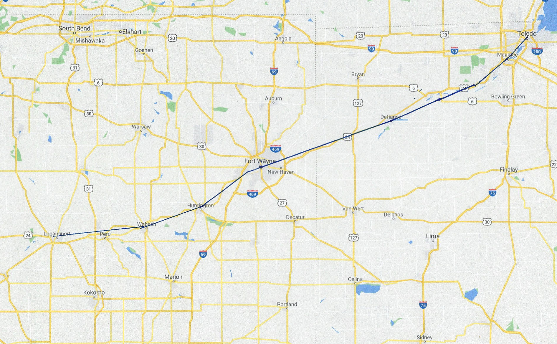
Arrived at Buffalo on Saturday noon Sept 17th and remained there over Sunday and Monday. At 10 AM started in the steamboat General Porter up Lake Erie. Went for 45 miles, [before we] struck a rock near Dunkirk and stove a hole through her bottom, ran her into the harbor where she sank a few feet from the wharf with 3 feet of water in her cabin, and 700 passengers on board, men, women and children of all sorts of sizes, ages, conditions making one little world by ourselves. What may seem incredible too is that boats leave daily from Buffalo with an average of 700 or 800 passengers, mostly immigrants moving to the west. Here we were—700 of us—shipwrecked in a little village of some 30 to 50 houses. Our company consisted of 7 men on shore while the others got out our baggage near up the wharf. [We] chartered a wagon to carry us 3 miles to the stage road at Fredonia. We got there and chartered the only stage there for $20 to take us to Erie PA—50 miles. Before our stage was ready, swarms of passengers arrived from the boat wanting conveyance but they arrived “just in season to be too late.” We went on to Erie and from there by stage to Cleveland Ohio, about 110 miles. We there got on board the steamboat Thomas Jefferson and arrived at Detroit Michigan in about 24 hours. We there breakfasted and took another boat, came back down the Detroit River across the westerly shore of Lake Erie to Toledo at the mouth of the Maumee River. Again took a steamboat and went 8 miles up the Maumee to Perrysburg, the head of navigation on that river. This was Friday evening.

On Saturday we purchased horses, saddles, bridles, portmanteaus, leggings etc and on Sunday at 2 PM commenced our tour up the Maumee River through the woods on horseback to Fort Defiance at the conjunction of the St. Josephs River and the Auglaize River, whose junction forms the Maumee. We made 18 miles and put up at a house (a tavern it could not be called) kept by a man, half-French, half-Indian. We had a comical supper and were put to bed in a chamber— 8 beds, or more properly, substitutes for beds, where we stowed away, 18 of us men women and children, windows with more than half the glass out, and we had to put in our hats and coats to fill in the gaps. The next day we reached Ft. Defiance after a 38 miles ride through mud & ravines almost perpendicular—down and up through mud sloughs, fording rivers, etc. etc.

Fort Defiance

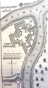
There is a little village at Defiance and a tolerable tavern where we fared comfortably. Fort Defiance is well named, it’s situation is most commanding being directly up the point where the two rivers meet, with the guns so arranged as to point down the Maumee and up the St. Joseph and Auglaize, with a high embankement and a deep ditch in the rear from river to river. I think troops stationed there might well defy an enemy. The village is situated directly in the rear of the fort and is very pleasant.

In leaving Ft. Defiance we commenced a journey of 50 miles through the forest where there was no road but for a path for man and horse through swamps [and] deep ravines. We would descend 50-75 feet almost perpendicular, the horses sometimes sliding from top to bottom unable to keep a foothold. At the bottom there were mud sloughs and water up to our horses bellies and immediately afterwards we would ascend almost perpendicular, obliged to hold onto the horses’ manes and let our horse keep prone step to step and with the greatest effort reach the top. The first night we put up at a log cabin of two rooms (about half a dozen of which were all the inhabitants there were between Ft Defiance and Ft Wayne—50 miles)


The Ohio and Indiana portions of Fay’s journey.

We had a supper I believe such as never before ate—meat that had been cooked some 8 or 10 times and fish which was not cooked without salt or butter. We were sent to bed under the roof (if roof it might be called) by a flight of stairs outside with no door and the logs so far apart that it appeared more of a cob house than a dwelling, stowed in with corn, oats, boxes, herbs, etc with 4 (what were called) beds. We stayed there till morning during a raging[?] night and had the same provision for breakfast and it was again set before 5 others travelers who came up just as we left.

The next day we passed Fort Wayne, a small little town, and commenced descending the Wabash River on a tow path of the Wabash Canal. That night we put up at a log house and had a splendid entertainment [the word here means “food and lodging”] as good as could be had in Boston. The next night we put up at another log house and fared comfortably. The owner was formerly from Massachusetts.

The next day we came to Logansport, a fine town in Indiana at the junction of the Wabash and Eel Rivers. In the meantime, I saw plenty of Indians and among them the head chief of the Miami Tribe who dresses and appears like a gentleman. He is said to be the richest man in Indiana, supposed to be worth $400,000. There was a collection of 11,000 Indians near Logansport to receive their pensions from government. But a quarrel ensued between them, and the whites and the militia [were] call out and two or three [Indians] killed before order was restored. We saw the troops just returning as we entered Logansport.

We left Logansport in the afternoon and went 6 miles to a small tavern on the banks of the Wabash and here my scene of troubles began….

TO BE CONTINUED….


More Treasures from the Basement


As I hinted last time, the basement hasn’t finished yielding up its social history treasures, for along with the Franklin Institute minutes, two weeks ago we also rediscovered the accounts of the Young Mens Lyceum.  As a document of social history, it is impossible to underestimate the value of this remarkable record.

The Lyceum was a debating society, much like the earlier Franklin Institute.  But this time, the notation covers the years between 1840-1861, perhaps one of the most turbulent periods in United States history, often referred to as the “Silver Age.” For in addition to the much debated Mexican-American War, our  expanding nation was dealing with the growth of  industrialization, a rapid rise in immigration, and the slow fragmentation of the Union over the issue of slavery. You might think that the inhabitants of agrarian Southborough would  have worried more about the local weather than the political clouds in Washington, but thanks to this record, we now know that wasn’t at all the case.

Here’s a look at some of the debate topics, with a bit of historical context added in, to give you a better understanding of just how up-to-the-moment our citizenry was:

29 November 1842: Which is the most beneficial to the United States: commerce or agriculture? (Voted 6 to 2 for commerce)
This is a very interesting result for what was then entirely agricultural Southborough, and shows that the rising tides of industrialization were beginning to spread out along the lines of the new railroad. Within the next decade, in fact, Southborough would have its first large-scale mill at Cordaville.

The mills at Cordaville originally produced cheap cotton cloth for the Southern slave markets, and only later turned to woolen blanket production,  highly ironic considering the fierce abolitionist stance of many Southborough inhabitants.

21 March 1843:  Have females the right to active part in public affairs? (Voted yes) The Lyceum, unlike the Franklin Institute, also seems to have had  a female “editress,” whose job appears to have been gathering news-bits of the day for presentation to the members.

22 February 1844: Is it right or expedient to prosecute vendors of spirituous liquors? (Voted 5 to 4 yes.) 
Massachusetts was technically dry during this period, but sellers of hard liquor weren’t hard to find, and the close vote is indicative of the popular stance — publicly opposed but privately for.  The state would try various solutions until eventually agreeing to license liquor vendors in the 1870s. Southborough remained officially dry even longer, and our thirsty citizens needed to cross the river to Hopkinton, where  those in search of  liquor, cards and other pleasures could find several famed houses of mixed repute.

Henry Clay, the “Great Pacificator”

23 September 1844: Can abolitionists consistently vote for Henry Clay? (Voted 2-6 against)
1844 was a presidential election year, and Henry Clay, the Whig candidate, was running against Democrat James Polk. Polk, from Tennessee, was a slave owner. Clay, from Kentucky, had also owned slaves, but was considered “soft” on slavery as he decried the institution and favored gradual emancipation and repatriation of slaves to Africa — a view shared at the time by Abraham Lincoln. Southborough, however, was a hotbed of abolitionists, and true to their convictions, the Lyceum members could not bring themselves to support Clay, despite his carrying the rest of the state.

24 December 1844: Are rewards of merit conducive to the best interests of our common schools? (Voted 4-5 against)
Corporal punishment was still a favored means of discipline in our schools in 1844. This practice would change markedly over the next twenty years, as Southborough formed a school committee and introduced semi-permanent female teachers, as opposed to the previous system of interim male tutors. Note, too, the date: 24 December. Christmas as a major holiday was still decades away, to be popularized by Queen Victoria’s German consort, Prince Albert.

3 March 1847: Ought the so-called free states remain in the Union? (Voted not to remain.) A very hot topic, this question was debated again on October, 6th, 13th and 20th. The vote taken on the 20th, 9-1 to remain in the union, reversed the previous opinion. Still not settled, the question was taken up once more, on November 16th and 22nd, this time the results being far closer, 8 to 6 to remain. This back-and-forth is truly fascinating, as it reveals that Southerners weren’t the only ones contemplating secession — something that’s never mentioned in our history texts — and that the residents of Southborough were more or less divided on the question. Imagine if the North had seceded and left the South to its own devices!  Alternate historians have speculated that lacking the industrialized north, the Southern states would have looked to the Caribbean and Central America for resource markets, extending slavery throughout the region.  A very different world indeed….


4 November 1848: Can a true patriot vote for Cass or Taylor for President at the coming election?

1848 was another presidential election year, and this time the candidates were even less palatable to the Lyceum members. Taylor, though nominated by the Whigs as the hero of the Mexican-American War, shared none of their values. Cass, a Southern Democrat, (though he was born in New Hampshire) was equally unacceptable. That left former president Martin Van Buren, who

Results of the 1848 election

ran as an independent.  The record of the Lyceum says it all: “The question was discussed for an hour and half but with little earnestness owing to the fact that there being no one to oppose from principle, and it was then decided 4-1 in the negative.”  This result should give some heart to modern day residents: it appears that the 2016 election wasn’t the first  where voters went to the polls holding their noses.

24 January 1849: Which contains the greater evidence of a supreme being, nature or the bible? (Voted Nature 5-1)
Given the Pilgrim founding of Southborough, this is another really interesting result, as you might have expected  more traditional religious views, but it seems that our Lyceum members shared more than a little streak of transcendentalism.

28 February 1850: Which has been treated worse, the Indians or the Negros? (Voted 7-1 for the Indians)

20 February 1850:  Is it probable that the country will be benefited on the whole by the discovery of gold in California? (5 to 4 against)
Southborough wasn’t immune to the call of California gold, and the Society possesses a fascinating series of letters from a former resident who left to try his luck — but that’s a story for another day.

23 February 1850: Which is worst, the slanderer or the thief? (Voted 4 to 2 for the slanderer)

16 October 1850: Ought Massachusetts sustain the Fugitive Slave Bill? (Decided unanimously against)
The Fugitive Slave Act, part of Henry Clay’s Great Compromise of 1850, allowed anyone suspected of being a fugitive slave to be arrested on merely the claimant’s sworn testimony of ownership. The law was widely despised and resisted in the North, as the residents of Southborough clearly reveal here.

31 March 1852: Is a monarchical or republican form of government better adapted to the promotion of the arts and sciences? (Voted  3-10 for the republic)

Great Britain has just hosted the Crystal Palace Exhibition showcasing British industry and arts, and this question is undoubtedly the result of some nationalistic chaffing.  Americans would have to wait until the Centennial Exhibition at Philadelphia in 1876 to see something similar.

22 December 1852: Should the annexation of Canada be encouraged? (8 to 6 for)
There was serious discussion in both the US and Canada (especially Quebec) about annexing all or part of Canada to the US, which wasn’t as far fetched as it sounds to us today. The Dominion of Canada had yet to be formed, and many viewed the territories to the north as ripe for acquisition, as the Alaska Purchase would confirm in 1867.

27 December 1859: Is the reading of fiction beneficial to society? (Voted no)
So much for Dickens! Interestingly, the Society, in conjunction with the Library, possesses the 1852 founding documentation (including book lists) for our Library, and its one of our future projects to study and digitize these records. It would be interesting to see exactly what books were considered “beneficial.”

3 January 1860: Is John Brown to be justified in his conduct at Harper’s Ferry? (Voted yes)
The 1859 raid on Harper’s Ferry was an effort by abolitionist John Brown to initiate an armed slave revolt by taking over the United States arsenal at Harpers Ferry, Virginia. It was put down by the US Marines, and Brown, a long-time resident of Springfield Massachusetts, was tried and hung for treason. That the residents of Southborough would support this violent action is indicative of just how fiercely anti-slavery many of the Town residents had become.

24 January 1860. Is one nation justified in forcing civilization upon another? (Voted no)
An astoundingly modern view, given the nationalism of the Victorian age.

26 March 1861: Should foreign immigration be encouraged? (Voted 15-6 no)
Hardly surprising in Southborough where the founding Yankees were beginning to feel the pressure of Irish immigration.

9 April 1861: The very last entry of this incredible record. The Civil War was about begin and soon many members would be putting courage to the same convictions they had earlier professed at the Lyceum.

“Owing to the small number present,” reads the record,  “it was thought best to have no discussion. Voted to adjourn sine die.”

And thus the golden age of Southborough’s debating societies came to a muted end, drowned out by the drums of civil war.

Neither the Town, nor the Nation,  would ever be quite the same again.


The Boston & Worcester Trolley Air Line

I often think as I get in my car to travel the three or four minutes from my home to the museum, how long this trip would have taken a hundred years ago. Granted, I might have had a car in 1917, but more likely for Southborough, I would have had a horse, and saddling a horse and riding those few miles is a half-hour operation at best. Walking is about the same (you save the time of saddling and unsaddling) and biking was (and is) about 10 minutes, with one major hill.

Imagine then how thrilling it must have been to go from Boston to Worcester in 2 hours by trolley! Now of course, train travel had been around since the 1830s, but with limited local service. The Boston & Albany’s tracks on the border with Hopkinton were a major freight line, as well the route of the named ‘varnish’ trains (the Boston end of the famed 20th Century Limited passed daily through Southborough, for instance) headed for New York, Chicago and all points west.

But on a trolley, all things were local. You could get on and off at will, plus, during the summer months the cars were open-air, and the route truly scenic.  Speaking of the Southborough portion west to Worcester, the booklet below simply glows:  “This portion of the road, running through woods and fields, with fleeting glimpses of all that makes the New England landscape famous, give the tourist a trip long to be remembered.”  To the east of Southborough the route ran through the middle of today’s Rt 9, the old Boston Worcester turnpike, which by the time of the Airline’s construction in 1901, had been largely abandoned.  It must have been an incredibly beautiful trip through the rolling hills of unspoiled countryside and quaint little villages, and in fact the Airline ran special cars for “Trolley Parties,” which were popular day-long excursions in the early 1900s.

The booklet below has never to my knowledge been published online, and is here represented in full size: just click on the images to expand. The very rare fold-out birds-eye view map is truly one-of-a-kind. The booklet is not dated, but can be reasonably assigned to the very first years of the Airline, as the map doesn’t show the White City Amusement Park, which became a major attraction on Lake Quinsigamond by 1905.

This first-time publication is the product of the Society’s continuing  efforts to share our history widely and make our collections accessible to all, and a perfect example of why we need and value your continued financial support.  Donations are easy to make online: just click the button at the end of this post.  More pictures of the Airline are available HERE.

In the meantime, enjoy this long-lost booklet, newly restored to view.

Click on any image below to expand

The fold-out map below is 30″ long and 24MB. But, you can browse to your heart’s content. Maximize your browser size to fully enjoy!

Won’t you make more wonderful finds like this possible?
Donating online is quick, easy and secure. Simply click the donate button below:

Lost Southborough: 3 Historic Railroad Stations

Ever wonder why Southborough lacks an historic railroad station, especially given the beauties that still exist in Framingham, Ashland, Westborough, and many other points along the old Boston and Albany line?

Well, in fact, we once had not one, but three!

The first, on the branch Agricultural Line to Marlborough, stood on Main Street, in the empty lot west of Lamy’s insurance:

It’s unclear what happened to this beautiful Queen Anne Structure after service was discontinued in the early 30s. Perhaps some of our older members might remember when this building was demolished? How we could use this building now as part of a revitalized main street! Wouldn’t it have made a fantastic pub?

My understanding was that Southville Station, seen below in its prime, was abandoned, vandalized and eventually demolished in the early 70s, the low-point of historical preservation in Southborough.

However, its near twin Cordaville Station had a different fate. I had heard tell that it had been moved to New Hampshire, but I was never able to confirm that.


Until now! Sorting through our files as we move back into our museum quarters, I discovered this remarkable clipping. Ho ho! A clue!

So now, do you suppose our once glorious station still exists somewhere in Dublin New Hampshire? I’ve contacted the Historical Society there, and hopefully we’ll soon find out.

Regardless, the sad lesson to be learned here is that if you don’t value your historical structures, there’s always someone else that does…. much to the detriment of your own surroundings.

Moving forward, we need to guard our historic heritage much more actively, Southborough friends!

When Southborough Was a Mill Town

A circa 1900 advertisement for Cordaville Woolen Mills

In 1847 Milton H. Sanford of Medford purchased several parcels of farm land along the Sudbury (then Concord) river in Southborough, Ashland and Hopkinton. One of them conveyed the mill privilege – the right to dam and use the water of the river. In addition to this ample power source, the area was attractive for milling because of the proximity to the new Boston & Worcester railroad, which ran through the site. Not only would transport to far-away markets be assured, but the railroad would supply the workforce needed for the new facility. Sanford began building workers’ houses on Parker and Cottage Streets, and by 1850, a company store on Main Street, later named Fitzgerald’s, which still stands. The village he named for his wife Cordelia.

By 1854 the Cordaville Manufacturing Company consisted of a cotton factory and a building that housed a machine shop and planing mill. The company produced a rough fabric for use by slaves on the Southern plantations, as well as woolens. (For reasons of culture and geography the South had few manufacturing centers of its own, and most industrial mill production was carried out in the the Northeast with its abundance of river power and ample immigrant work force, then shipped southward.)

millonpondcordaville web
The mill pond with the mill buildings, looking east

The workers for Sanford’s mill were largely newly arrived Irish immigrants, who had fled the devastating potato famine that had begun in 1847 and would eventually lead to the emigration of almost 2 million souls. Approximately sixty workers were employed at the mill; two-thirds were women, and paid only half that of their male counterparts.  The influx of Irish to the mill caused the first Catholic mass to be said in Southborough, on Easter Day 1849, in Wilson’s Hall above the company store.

A fire — a very common occurrence in mills with their highly flammable cotton dust — destroyed the original mill complex and killed three workers in 1855. It was rebuilt, this time including both water and steam-powered apparatus. With the outbreak of war, Sanford quickly abandoned the manufacture of plantation goods, and instead manufactured woolen blankets for Northern troops. This quick response allowed his Cordaville mill to survive when many competing mills failed due to the loss of the Southern market. The mill’s location on the principal rail line between Boston and points West also helped; it was a major transport line for the Federal army.

In 1864, the complex was sold and the business converted to a joint stock venture, the Cordaville Mills Company. By 1870, the mill had grown considerably. There were now two mill buildings, an office, three freight houses, a waste house, a picker house and factory store, now operated by the Wright brothers, which also housed the post office. The village of Cordaville grew with the addition of its own train station, school, and in 1872, St. Matthews Church; and in 1876, a jail. That same year, the company was reorganized as the Cordaville Woolen Company, and the shift to steam power, already underway, accelerated — aided by a prolonged period of drought in the 1880s that dried up many mill ponds. Once again, this timely shift to steam allowed The Cordaville Woolen Company to remain a profitable concern well into the next century.

b&a station
Cordaville Station with Fitzgerald’s visible behind

By 1928 however, the corporate model of a company owning an entire village seemed out-dated and unprofitable, and the Cordaville Woolen Company was sold off in pieces. Individual workers were allowed to buy their homes if they wished, and the owner of the company store, a certain Mr. Fitzgerald, purchased it as well. Under various owners the mill buildings continued in one industrial capacity or another until 1957. After that, the buildings sat abandoned; by 1974 the complex was deemed unsafe, and was torn down by the Town of Southborough, which sold off the bricks of the once proud buildings. (The fate of the mill buildings much resembled that of Cordaville’s H.H. Richardson-designed train station, which the Selectmen voted to demolish in the 70s with seemingly little public opposition. The stone was sold to a builder in New Hampshire.)

The loss of the Cordaville Mills is but one of Southborough’s many historical “if-onlys”.  If only the buildings had been allowed to survive a little longer, the nascent historical protection movement would have realized their incredible value as a mixed commercial, office or residential site. Can you imagine how handy a condo complex with a hip restaurant and bar right next to the commuter rail station would be viewed by today’s consumers? Or how much land might have been preserved from controversial state-mandated 40B projects if we had converted the complex to affordable housing and filled Southborough’s quota of units? Of course hindsight is 20-20, but Southborough needs to be far more vigilant these days in protecting its remaining architectural heritage.

More images of industrial Cordaville and Southville:

A Short History of Route 9, The Road You Love to Hate

For those of you stuck almost almost daily in gridlocked traffic on Route 9, staring at nothing but ugly concrete Jersey barriers and electronic billboards advertising products you don’t need, we thought you might like to read about life in another time, and how the road you love to hate came into existence in the first place.

The following are excepts from a charming account read before the Brookline Historical Society December 26, 1906, by Edward W. Baker ~Eds.

In the summer of 1906, a few enthusiastic golfers planned a day’s play at the Worcester Golf Club, and one beautiful summer morning we assembled in Village Square, Brookline.

We boarded the open electric car marked “Wellesley, Natick, Framingham and Worcester” at almost the identical spot where, years ago, we would have climbed into a great, lumbering, four or six-horse coach. Probably in those days we would have preceded our departure by drinking a mug of cider or flip, or perhaps a little spiced wine, in the tap room of the old Punch Bowl Tavern, which stood on the northerly side of the square, and whose hospitable doors were always open under the sign of the Bowl and Lemon Tree.

whitescornertrolley
This is the “Air Line” trolley station stop at White’s Corner, 1904. It was here the train branched off into open country, regaining the Turnpike past Westborough.

Until the town line was reached, just beyond Hammond street, the car kept the rate of speed to which we are accustomed within city limits, but, after reaching the open country in Newton and beyond, the speed increased to express train rate and we whirled along smoothly and so rapidly that about two hours after leaving Brookline we reached the square in Worcester.

It was a most delightful ride in the fresh morning air, through beautiful scenery of hill, valley and meadow, amid surroundings of great interest, both on account of their present significance and historical associations. The return trip was under the light of a clear, bright moon, and, if anything, was more pleasurable than the outward journey in the morning. The next week the same party took another ride in the same way as far as Framingham, where the day was spent at the Framingham Country Club, whose grounds are opposite one of the recently completed basins of the great Metropolitan Water Supply system, and whose club house, directly on the line of the car route, is the old Josiah Temple house, built in 1693 by Caleb Bridges, and adapted in a most artistic manner to its present use.

These trips brought vividly to the writer’s recollection an outing which he enjoyed with a schoolboy companion sometime in the seventies, when, with a horse and buggy, we drove from Brookline to Worcester, taking two days for the trip, with stop-over at Westborough, which was reached late in the afternoon of the first day. After spending some weeks on a farm a few miles beyond Worcester, we drove back to Brookline.

Going and coming we kept to the old turnpike road, which the trolley cars now follow, and, boy-like, we went prepared for adventures with highwaymen and possible savage beasts. But the journey was lacking all such excitements, and gave us only the experiences of a drive along a quiet, little-used, and in. some places almost forgotten country road, narrow and grass-grown for long stretches, over-shadowed by the foliage of the low-bending trees and bordered by vines and wild flowers.

The contrast in the manner of traveling, and the great changes along the road which have taken place in the last thirty years, emphasize the fact that the extension and improvement of the means and methods of traveling are the most important factors in the growth and development, not only of the termini served, but of all the intermediate country, and every town between Worcester and Boston has waxed or waned in its growth and progress according to its facilities far transportation…

History is the story of successions and the causes thereof.

Before the white man settled on Shawmut, as the old peninsula of Boston was called, the Indians had their paths or trails westward through the wilderness between the Bay and their settlements on the inland lakes and streams in the Connecticut Valley and beyond.

When the Wabbaquassets came from what is now Woodstock, Connecticut, with sacks of Indian corn for the nearly starved colonists in the fall after Governor Winthrop arrived (1630), they travelled to and fro by one of their trails which no doubt had been frequently travelled before and was easily followed by what were to them well known landmarks.

The earliest English travellers westward, so far as known, were John Oldham, Samuel Hall and two others who, in 1633, started for Connecticut to look for a good place for a new settlement, as if anywhere within twenty miles of Boston was not new enough in 1633!

Knowing of the trail used by the Indians three years earlier, they followed it from Watertown, because they realized it would be the easiest line of travel; would strike the fording or crossing places of streams, avoid bad swamps, and, what was of equal if not greater importance, would take them by the Indian villages scattered along the route, where they could obtain food and lodging.

Boston_Post_Road_map
A map showing the colonial post roads. (Click to enlarge) From this it’s easy to see how a more direct route straight west to Worcester seemed like a good idea — and indeed it was, for the railroads!

Other pioneers started out by the same route, and little by little the original trail became recognized as an established line of travel. Followed by larger parties and by those who took their families, their horses and cattle, the faintly marked path became deeply worn and clearly defined. It was known as “the way to Connecticut,” [Today’s Rt 20, ~ eds.] and the early records of grants of land in what are today Wayland, Sudbury, Marlborough, and other towns specify areas of more or less acres along the “Connecticut Path,” as it was designated, which, after it became still more broadly marked, was named the” Connecticut Road.”

In what is now Wayland, formerly a part of Sudbury, the old path forked. The northern branch, passing through Marlborough, Worcester, and Brookfield, was known as the” Bay Path,” [Today’s Rt 20; the southern fork is now Rt 126; see the map at left ~eds.] and extended straight to the Connecticut River and the settlement of Agawam, now the City of Springfield.

With the growth of the Colony the travel in both directions grew heavier and heavier, and in the progress of time what had been a path through forest and across clearing, faintly traced by the soft moccasins of the Indians, developed into what was termed “The King’s Highway.” After the Revolution, it lost its royal title, and is commonly referred to in the records as “the great road” or the” post road from New York to Boston.”

For over one hundred and fifty years the “great road” was the trunk line to Worcester, but the zenith of its glory was reached just one hundred years ago, when, so far as” rapid transit” was concerned, it was rendered quite out of date by the building of the Worcester Turnpike in 1806 and 1807.

Chapter 67, Massachusetts Acts of 1806, incorporated the Worcester Turnpike and authorized Aaron Davis, Luther Richardson, Samuel Wells, Charles Davis and William H. Sumner, Esquire, to layout a turnpike from Roxbury to Worcester, “commencing at or near Roxbury street and running near the house of Stephen Higginson, Jr., in Brookline, thence near Mitchell’s Tavern in Newton, thence crossing Charles River near General Elliott’s Mills and running near the house of Enoch Fiske in Needham (this part of Needham is now Wellesley), thence to the Neck of the Ponds, so called, in Natick; thence near the house of Jonathan Rugg in Framingham; thence near the house of Deacon Chamberlain in Southborough; thence near Furbush’s Tavern in Westborough; thence near the house of Jonathan Harrington in Shrewsbury; thence crossing Shrewsbury pond and running north of Bladder pond to the street in Worcester near the Court House; with power to erect four toll gates thereon, at such places, not being on any old road, as the committee appointed by the Act shall determine.

The proprietors were authorized to demand and receive at gates where full rates were charged, the following tolls:

  • For each coach, chariot, phaeton or other four-wheel spring carriage drawn by two horses – 25 cents., and 2 cents. for each additional horse.
  • For every wagon drawn by two horses – 1O cents., and 2 cents for each additional horse.
  • For every cart or wagon drawn by two oxen – 10 cents and if by more than two, 12 1/2 cents.
  • For every curricle – 1 cents.
  • For every chaise, chair, sulkey, or other carriage for pleasure, drawn by one horse -12 1/2 cents
  • For every cart, wagon or truck drawn by one horse – 6 1/4 cents each.
  • For every man and horse -4C. For every sleigh or sled drawn by two oxen or horses – 8 cents., and 1 cent for each additional ox or horse.
  • For all horses, mules or neat cattle led or driven besides those in teams or carriages – 1 cent each.
  • Swine or sheep – 3 cents by the dozen.


80-11.12 view from stepple copy
In this incredible view, taken from the steeple of Pilgrim Church before the Civil War, you can appreciate how open and rural travelers on the Turnpike would have found Southborough, and how happy they would be to settle into a cup of ale or hard cider at Woodbury’s Tavern after struggling up the hill in Fayville. The Turnpike’s lack of respect for topography meant it could never be used for significant freight as teams could not make it up the most severe grades.


Certain exemptions were made by which no tolls could be demanded from foot travellers; from those driving to or from their usual place of public worship; from those passing on military duty; or from those living in the town where the gate was located, unless they were going beyond the limits of the town: and one could also go without charge to and from the grist mill, or on the common and ordinary business of family concerns.

It was supposed that this turnpike would give the maximum speed in the minimum time because it was laid out on the simple mathematical principle that a straight line is the shortest distance between two points. The turnpike engineers paid little attention to grades, and seemingly forgot that the actual distance traveled may be as long over a hill as around its base, to say nothing of the greater effort to the traveler climbing up one side and holding back when going down on the other.

Stagecoach and tavern days reached the high level of their development along the line from Boston to Worcester from 1830 to 1835, after which the once popular route took its place in history as the “Old Worcester Turnpike,” its usefulness almost entirely taken away by the completion of the Boston and Worcester steam railroad….

Cordaville Crossing
Passengers at the Cordaville Road train station. From the 1840’s to 1900, the easiest way to go to Boston, or to any point east or west for that matter, was to take the train.

Although of great benefit to the traveling public [for three decades], the Worcester turnpike did not prove a profitable enterprise to its proprietors, even with sub-divided tolls. It paid few dividends, never six per cent, and finally the whole capital involved was totally lost. [Another cause of financial failure was active toll-avoidance on the part of many who used the road without payment, simply detouring around toll gates. Eds.]

[After the 1850s} there was little if any through-travel, and except for short stretches through the populous sections of towns, it retained not a shadow of its former popularity. Moss-covered stone walls or dilapidated weather-beaten fences marked its bounds; with here and there a turnout to enable the thirsty horses or cattle to drink from some clear-watered brook which flowed lazily under the roadway. The quiet and peacefulness along the way was undisturbed except by the clatter of the bell on some cow’s neck as she fed along the faintly marked side-path on the way to and from the nearby pasture.

For over fifty years, the old turnpike dozed and nodded in this sleepy sort of a way, until in the first years of the twentieth century its slumbers were disturbed by the sudden shock of the electric current, which, revolutionizing nearly every form of industry, has affected the problem of transportation in particular. Again the engineers and contractors covered the ground, and when they had finished their work the old road was so altered in appearance that never again can it be recognized, even by itself.

91.3.11 Italian Workers on the trolley copy
After the work on the reservoirs was complete, many Italian immigrants stayed to work on the new trolley line. Here the tracks are being laid in Southborough.

Today, the “broom-stick trains leave ye ancient highway in Brookline where the arch stands” for “the street in Worcester near the Court House” every half hour or less, and carry thousands of coach-loads of passengers at high’ speed, without dust, cinders, or other similar discomfort. Every seat is an outside seat in pleasant summer weather, and in cold or stormy weather the easy-riding cars are well warmed and comfortably furnished. In 1906, we might repeat the words of the historian of seventy years ago, when he said in regard to the stage coach lines of 1836, “the speed of traveling and its facilities have been increased almost beyond measure.”

Editor’s Note: We wish the sentiments of 2016 were equally so optimistic. With the rise of automobile ownership after the invention of the Model-T Ford, public transportation began a rapid decline. In 1930, both to accommodate rising automobile traffic and to provide a works-project during the Depression, the State decided to remove the trolley line and lay a four-lane concrete highway over the Boston-Worcester route, naming it Rt 9. As the predecessor of the modern freeway, it brought all the problems that we today associate with urban sprawl to communities west of Boston, essentially dooming the road (except in a few remaining short runs here and there) to be one long concrete commercial corridor. State planners estimate that the land along the roadway remains only half “built out” and predicts a doubling of the current traffic by 2030.

90.10.142 Little Deefoot Barn copy
Route 9 in the 1940s, looking east on the Southborough border with Westborough, almost unimaginably different today.